Research Projects
My research interests are centered around high resolution climate modeling, mesoscale convective systems, and model/data comparison.
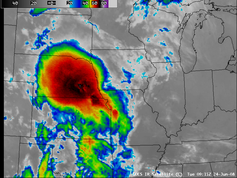
Ingredients-based examination of heavy rainfall events


This project was part of my experience with the William M. Lapenta Internship Program at NOAA.
Quick overview
Flash floods are dangerous because they can happen very quickly and cause serious damage. In this project, I study what makes the worst rain storms different from more common ones by looking at weather patterns before heavy rain events across the United States. I focus on how moisture and winds move into an area and how storm conditions build up before flooding begins.
I find that the most extreme floods usually happen when large amounts of moisture are pushed into a region, sometimes slowly and sometimes all at once. This research helps weather forecasters better recognize when heavy rain could turn into a dangerous flash flood, helping communities prepare and respond more effectively.
Scientific abstract
Flash floods are high-impact events that pose great threats to public safety, infrastructure, and economic stability across the United States. The most severe flash flooding events occur during periods of intense rainfall, making it essential to improve our understanding of the meteorological ingredients contributing to these events.
In this study, we investigate the evolution of key meteorological factors preceding rainfall events exceeding the 2-year and 100-year Average Recurrence Intervals. Using NOAA Stage IV rainfall data, significant rainfall events across the entire year of 2024 were identified using the Method for Object-based Diagnostic Evaluation tool within the METplus verification suite. To capture the temporal evolution of meteorological ingredients, we analyzed High-Resolution Rapid Refresh (HRRR) analysis data at the event onset and at intervals of 3, 6, and 12 hours preceding each event. Key parameters examined include 500 mb geopotential height and vorticity, upper- and low-level winds, precipitable water, moisture transport, most unstable Convective Available Potential Energy (MUCAPE), and Corfidi vectors. We created spatial composites of these meteorological ingredients for six distinct U.S. regions (West, Southwest, Northern Plains, Southern Plains, Northeast, Southeast) on both annual and seasonal scales. We additionally examined differences in the distribution of atmospheric ingredients between 2-year and 100-year ARI events.
Our results suggest notable regional and seasonal variations in the meteorological conditions that precede significant rainfall events. We show that moisture transport gradients at 850 mb and 925 mb most strongly distinguish 100‑year from 2‑year events, with event centroids aligned on these moisture axes. Precipitable water provides a strong contrast between 2‑year and 100‑year events in the Northern Plains and Northeast—whereas in the Southern Plains and Southwest, 100‑year events were marked by a pronounced moisture surge. MUCAPE gradients were most pronounced in the Southwest and Northern Plains, highlighting their role in extreme flash floods. Ultimately, these insights will be translated into an operational tool for NOAA’s Weather Prediction Center MetWatch desk, strengthening real-time flash flood monitoring and warning.
Equilibrium Climate Sensitivity Across Cenozoic Warm Intervals

Quick overview
In this project, I try to understand how much the Earth warms as carbon dioxide, which traps heat in the atmosphere, increases. Scientists still disagree on how much warming to expect in the future, which makes planning and decision-making difficult.
Modern measurements only show recent climate conditions. To understand a wider range of possibilities, I studied several periods in Earth’s past when carbon dioxide levels were higher, making the planet warmer and changing how much snow and ice covered it. Together, these periods help show how Earth may respond as human-caused warming continues.
To estimate how warm the planet was during these periods, I used natural evidence preserved in ocean mud and fossils. I then combined these estimates with results from many climate model experiments. I found that carbon dioxide caused more warming during cooler periods, when large ice sheets were present. This suggests that future warming could be especially strong during times when ice sheets are present and vulnerable to melting, meaning even small changes in future warming could have large consequences.
Scientific abstract
Equilibrium climate sensitivity (ECS) quantifies the amount of warming resulting from a doubling of the atmospheric CO2 forcing. Despite recent advancements in climate simulation capabilities and global observations, there remains large uncertainty on the degree of future warming. To help alleviate this uncertainty, past climates provide a valuable insight into how the Earth will respond to elevated atmospheric CO2. However, there is evidence to suggest that ECS is dependent on background climate warmth, which may interfere with the direct utilization of paleo-ECS to understand present-day ECS. Thus, it is important that a range of different climate states are considered to better understand the factors modulating the relationship between CO2 and temperature. In this study, we focus on three time intervals: the mid-Pliocene Warm Period (3.3 – 3.0 Ma), the mid-Miocene (20 – 11.6 Ma), and the early Eocene (~50 Ma), in order to sample ECS from Cenozoic coolhouse to hothouse climates (see image above). Here, we combine a linear framework of constraining the ECS and its uncertainty with several published methods to estimate the global mean surface temperature (GMST) from sparse proxy records. This framework utilizes an emergent constraint between the simulated GMST changes and climate sensitivities across the model ensemble. For each time interval, we employ a combination of parametric and non-parametric functions, coupled with a probabilistic approach to derive a refined estimate. Preliminary results for the Pliocene indicate a GMST reconstruction of approximately 19.3°C, which is higher than previous estimates that were derived using only marine records. Using this estimate, we calculate an ECS that is also higher than previously published values, especially due to the inclusion of high-latitude terrestrial temperature records into our estimates. Intriguingly, using the consistent methodology, our calculated ECS for the early Eocene and the mid-Miocene are lower than that of the mid-Pliocene. This result does not support an amplified ECS in hothouse climate, and points to a potentially important role of ice albedo feedback in amplifying the ECS in coolhouse climate. Ongoing work will conduct sensitivity testing and further investigate the source for the estimated ECS state dependency between these climate intervals.
Tracking Mesoscale Convective Systems
Example of a mesoscale convective system developing over Nebraska (https://cimss.ssec.wisc.edu/satellite-blog/archives/673)
Quick overview
Large storm systems called mesoscale convective systems produce some of the heaviest rainfall on Earth, but they are difficult to study in past climates without very detailed climate models. In this project, I use global climate model simulations to track these storms across climates ranging from icy periods to extremely warm worlds. I find that as carbon dioxide increases, these storms tend to shift toward the poles, produce more rain, and account for a larger share of yearly precipitation. The storms also look different in warmer climates, suggesting that how we identify them may need to change as the climate warms.
Scientific abstract
High-resolution climate models are essential for resolving finer-scale weather systems, which are among the most impactful effects of climate change. However, the study of mesoscale convective systems (MCSs) throughout Earth's history has been limited by computational constraints. This project aims to track MCSs across multiple paleoclimate intervals using a series of fully coupled high-resolution (HR) climate simulations, including the mid-Holocene, Last Glacial Maximum (LGM), mid-Pliocene Warm Period (mPWP), and Early Eocene Climatic Optimum (EECO). These simulations are run using the water isotope-enabled version of CESM1.3 with an atmospheric and land resolution of ~0.25° and an ocean and sea ice resolution of 0.1°, enabling the presence of organized mesoscale systems and an eddy-resolving ocean component.
This study investigates whether changes in MCS characteristics scale with global mean temperature, similar to patterns observed in extreme precipitation events. Preliminary results indicate a poleward expansion in MCS activity with increasing atmospheric CO2, accompanied by a general increase in MCS precipitation and a higher contribution of MCSs to annual total precipitation. Furthermore, we find that higher surface temperatures correspond to elevated levels of outgoing longwave radiation and brightness temperature, indicating the presence of warmer high cloud tops associated with these storm systems. This change in cloud-top temperature, a commonly used metric for tracking MCSs, suggests a shift in the characteristics that define these storm systems compared to present-day conditions. By examining MCSs across these diverse climate states, we aim to further uncover patterns and relationships between storm characteristics and global temperature.
More info! :)
This research is part of a larger PaleoWeather project and will provide valuable insights into past hydroclimate changes and contribute to more accurate predictions of future MCS behavior in a warming world.
This work began with the development of a new MCS tracking algorithm using a deep learning model, which was done in collaboration with Dr. Maria J. Molina at the University of Maryland. Publication of our model is still in prep for submission to Geosci Model Dev. This model was used in a new MCS tracking intercomparison effort (MCSMIP; published in JGR Atmospheres) and is now being applied to the suite of high-resolution paleoclimate simulations described above. See more about MCSMIP here--our tracker is the "DL + TempestExtremes"!
Mid-Pliocene North American Monsoon

Quick overview
Climate models often suggest that the North American summer monsoon would weaken as carbon dioxide levels rise, which could have major impacts on water resources and communities in the region. However, evidence from Earth’s past tells a different story: during the mid-Pliocene, a warm period similar to a possible future climate, the monsoon region appears to have been wetter than it is today. In this project, I use climate simulations and storm-tracking methods to understand why.
I find that the increased rainfall was driven by more frequent and intense large storm systems, which only appear in detailed models and are linked to greener land surfaces. These results show that capturing small-scale storm processes and land-surface changes is critical for accurately predicting monsoon rainfall in a warming climate.
Scientific abstract
Climate models suggest a weakened North American summer monsoon (NAM) under elevated atmospheric CO2, posing serious challenges to NAM region's socioeconomic development. This outlook is consistent with simulations of the mid-Pliocene (3.0 - 3.3 Ma), the closest analog to the middle-of-the-road future scenario. However, proxy evidence reveals enhanced summer precipitation in the monsoon region during the mid-Pliocene, raising questions about the climate projections. Here, we develop novel coupled high-resolution atmosphere-ocean simulations and utilize a feature tracking algorithm for mesoscale convective systems. Using these tools, we show that this summer precipitation enhancement reflects enhanced mesoscale convective system activity during the mid-Pliocene--an effect that emerges only in high-resolution simulations and results from land surface greening. These results highlight the importance of resolving surface albedo-moist convection interactions in modulating hydroclimate conditions in semi-arid continents, where the skill of climate hindcasts and projections are likely limited by model resolution.
This project is completed and is in review at Nature Communications!

Results from simulations using the Community Earth System Model showing wetter conditions during the Pliocene on the Eastern side of the Sierra Madre Occidental mountains in the high resolution simulations (right)
See MG present preliminary results of this work during the beginning of her PhD here!
Greenville County, SC, Farmland Conservation (Undergraduate Thesis Project)
This work was published in the Journal of Land Use Science! Check out our paper here.
Scroll through below to see an overview of my research as an undergraduate at Furman University